Earlier this week, Twitter user @TransitJakeTO floated the idea of turning Rosedale Valley Road and Bayview Avenue south of River Street into car-free zones. There is certainly a good case to do this for Bayview given the lack of destinations between River Street and Corktown Common, as well as the fact it was turned into a one-way southbound street last year to accommodate a new multi-use path.
 |
| ActiveTO on Bayview before the road was reduced to two lanes |
To take some inspiration from Matt Elliott’s intersection inspections from his City Hall Watcher e-newsletter, I reviewed traffic counts on that part of Bayview which fell by 73% from 5,568 on March 29, 2018 to 1,508 on March 24, 2022. However, I would like to explore Rosedale Valley Road a little deeper.
Rosedale Valley Road is seen by drivers as an alternate route from Yonge and Bloor to the Don Valley Parkway which bypasses a fair number of intersections and traffic signals. Excluding June 2020, between 10,000 and 13,000 cars used Rosedale Valley Road daily. Given this reality, banning cars on that street would be considerably more difficult than on the southern part of Bayview.
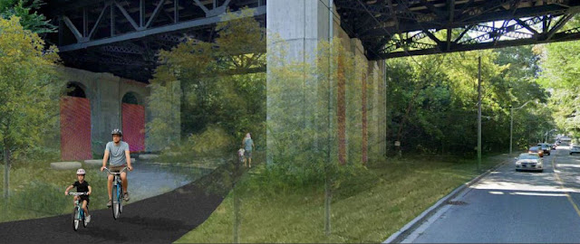
However, it doesn’t mean that Rosedale Valley Road couldn’t benefit from some improvements. The multi-use path from Park Road to Bayview Avenue is very narrow and bumpy, which is expected to be upgraded sometime this year in conjunction with the Glen Road pedestrian bridge replacement.
 |
| Proposed Rosedale Valley Road trail (via City of Toronto) |
One glaring omission from this project is the trail ends abruptly at Park Road with no connection to other bikeways such as those on Bloor and Yonge Streets.
The most logical solution would be to extend the Rosedale Valley trail west along Aylmer Avenue to Yonge Street. However, Aylmer Avenue is only seven metres wide and has a bridge crossing the Line 1 subway; making widening prohibitively expensive. Extending the trail would require making Aylmer one-way from Yonge Street to 100 metres west of Park Road where Rosedale Valley branches off to serve some apartment buildings and Severn Creek Park. There would be enough green space to build a trail on the remaining 100 metres.
As for which way the one-way treatment would be most appropriate, eastbound traffic shows slightly higher volumes and would make one way eastbound the most appropriate. Not to mention, heading towards the Don Valley Parkway would be a more direct shot. One disadvantage is the trail would need to be placed on the northbound side; thus requiring two traffic signal crossings instead of one.
Here is a very rough mock of how the proposed configuration could work.
By making Aylmer one way eastbound and extending the Rosedale Valley trail to Yonge Street, a key gap in Toronto’s trail network can be filled in which can provide people biking a shortcut from Yonge Street to the Lower Don trail system. It would be a relatively inexpensive fix and one that can help reduce traffic on Rosedale Valley over the long term.


That's a really good idea. I hope someone in charge is reading.....
ReplyDeleteIsn't there plenty of green space west of Severn to keep the path off the road up to to the bridge? A couple of downed trees and some re-grading would be an easier sell than closing off yet another lane of traffic. Shared sidewalk to Yonge, and done.
ReplyDeleteI did a measurement of the bridge. The north sidewalk is 2.3 metres wide which should be possible to widen to at least the three metres needed for a MUP while still having enough space for two car lanes. However, one consideration that will be needed is pedestrian traffic. Any routes with high pedestrian volumes would need separate walking and cycling spaces. Of course, you could extend the south/west sidewalk from the bridge down to Park Road in that case. If city staff were to look at this, I would be curious to find out what they would come up with.
Delete