May 10, 2019

The Pedestrianized Folly of yongeTOmorrow

Thursday, May 9 marked the first yongeTOmorrow open house, which aims to reconstruct Yonge Street from College to Queen Streets with a second phase extending north to Davenport Road. With pedestrian volumes making up between 50 and 75% of mode share there and low traffic volumes compared to nearby streets, the focus has been more on improving the pedestrian realm while public consultation documents mused about “installing cycling facilities on Yonge Street or a nearby north-south street”. Ryerson University’s City Building Institute posted an article citing their preference for bike lanes on adjacent streets; claiming bike lanes on Yonge would lead to pedestrian-conflicts and a reduced ability to host special events. While I am normally supportive of Ryerson CBI’s initiatives and acknowledge their support for Transform Yonge in North York, this is one of the few cases where we have to disagree.


The Perennial North-South Challenge
Hundreds of people attended the May 9 yongeTOmorrow event
As discussed previously, the lack of north-south cycling routes in Toronto – most notably north of Davenport – can make getting around by bike frustrating. Looking at a map of Toronto reveals there are not many opportunities to build continuous north-south bike routes from the Waterfront to the Steeles Avenue border. One of these is Yonge Street, whose Downtown and North York stretches are included in the bike plan approved in 2016 while the Midtown stretch was put on hold pending the bike plan update due at the Infrastructure & Environment Committee in June. The recommendation for bike lanes on Yonge goes even further back to 1977 covering Wellesley to Queen.
Continuous north-south opportunities with Yonge marked in purple
The next closest north-south option is two kilometres west on Bathurst Street and another four kilometres west gets you to Parkside-Keele-Weston. If you don’t count the recreation focused Don River Trail system, the next closest option east of Yonge is eight kilometres away at Victoria Park Avenue! Among the two adjacent streets proposed for cycling facilities, Bay Street only goes up to Davenport and Church Street doesn’t connect with the Waterfront. Factor in the large number of trip generators (e.g. Eaton Centre, Ryerson University, Yorkville, Yonge-Eglinton, North York Centre) – as well as higher advocacy efforts on Yonge compared to other north-south corridors – and it becomes clear Yonge is the only realistic option for a continuous north-south cycling corridor.

The Long List of Options

This open house presented a long list of options ranging from the four lane status quo to full pedestrianization and others in between. Some identified cycling facilities on only one side, while the options without two-way cycling made a reference of accommodating bike lanes on adjacent streets.
Car Free Option B with the bike path does the best job in balancing the interests of people who walk and bike (via City of Toronto)
The full pedestrianization option does not delineate space for people on bikes; meaning they would end up riding very slow if allowed at all. People who are visually impaired would have difficulty identifying bikes and the overall pedestrian-cyclist conflict risk increases. A more appropriate car free solution would be to install a bike path in the middle with identifiably different surface treatments to help the visually impaired. The curbs separating the bike path and wide sidewalks could be blended (e.g. Sherbourne cycle tracks) to improve accessibility for people using wheelchairs and other mobility devices. Some people were concerned with the car free with bike path option claiming people riding bikes would go faster and increase collision risk, but many supported this idea as a way to get bikes off the sidewalk.
Reducing Yonge to two lanes with protected bike lanes won't give people who walk much more space
Among the options which retained some motor vehicle capacity, the option I was more supportive of was the two traffic lanes with bike lanes on both sides provided they are protected. However, this would not give people who walk much more space than they do now and public realm improvements would be limited. I could only see this option working if going car free were to be ruled out.
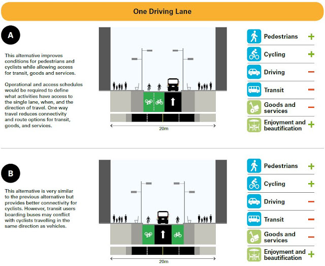
Some of the one lane options available though others without bike lanes were also presented
The one traffic lane options would leave questions of which way traffic would go and how to manage deliveries and passenger loading. The three lane options should be written off, given the lack of new pedestrian space and the inability to install cycling facilities both ways.
The three lane options presented do not offer much for people who walk or bike
Next Steps

The final environmental assessment on yongeTOmorrow isn’t due until Summer 2020 and there will be two more events in Fall 2019 and Spring 2020 to further refine the options. Based on the information available, I would recommend the car free option with the bike path, while the two traffic lane and protected bike lane option being the second choice. With people continuing to bike on Yonge regardless of what happens, any final recommendation must include dedicated cycling facilities on Yonge.
Some of the comments collected throughout the evening
The City of Toronto is collecting feedback through this survey until May 24, though people need to manually key in the need for protected bike lanes. More detailed feedback can also be e-mailed to yongetomorrow@toronto.ca.

Forever Yonge!
Rob Z (e-mail)

No comments:

Post a Comment