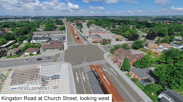
Last month, the City of Toronto made a mistake by removing the Brimley bike lanes within days of a public meeting deceivingly labelled as “improving Toronto’s cycling network”. Had the Brimley bike lanes been kept and extended, there is another project which could have provided a connection opportunity. It’s a project which could provide an intercity cycling connection between Toronto and Durham Region while also improving transit in the area.
That project is the Durham – Scarborough BRT.
 |
| A typical street layout for the Durham - Scarborough BRT (via Metrolinx) |
The Durham – Scarborough BRT aims to provide improved bus service along Kingston Road (Highway 2) and Ellesmere Road from Simcoe Street in Oshawa to Grangeway Avenue in Scarborough. Most of the route will have centre running bus rapid transit (BRT) lanes with stops placed past the traffic signal to improve transit operations, while cycling infrastructure will be included for a large part of the project. In Toronto, a boulevard path already exists on Ellesmere from Scarborough Golf Club Road to Orton Park Road as part of The Meadoway and a new trail segment is under construction from Scarborough Golf Club to Markham Road. Another short bike lane currently exists on Kingston Road at Port Union Road.
 |
| Map of western portion of Durham - Scarborough BRT and potential connection to the (now former) Brimley bike lanes with existing Ellesmere trail marked with a solid green line |
While all of Ellesmere Road will include cycling infrastructure from Grangeway to Kingston, a bi-directional boulevard path will be used on the south side from Orton Park to Military Trail at University of Toronto Scarborough and unidirectional cycle tracks will be used for the rest of the route. I would recommend extending the Ellesmere cycle tracks one kilometre west to Brimley Road to provide a safe connection to the Scarborough Town Centre. This connectivity potential would have been further improved had the Brimley bike lanes been kept and extended to at least Ellesmere.
Since crossing Highway 401 requires going through the Ontario Ministry of Transportation, the segment from Ellesmere to Port Union will be designed in consultation with that Ministry. Let’s hope protected bike lanes are included to connect the Ellesmere bike lanes with those found on Sheppard Avenue and planned for Port Union Road as part of future road widening.
 |
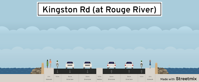
| Existing conditions of Kingston Road (at Rouge River) are above. Note how simply narrowing the traffic lanes can prove enough space for a proper cycle track across the bridge in the bottom rendering? |
Unfortunately, the project does not propose anything from Port Union to Altona Road in Pickering; thus leaving a significant connectivity gap between Toronto and Durham Region. The bridge currently has 1.5 metre wide edge lines – barely enough for a bike lane – while the four traffic lanes are each 3.6 metres wide and the centre median is 1.3 metres wide. All that’s needed for proper cycle tracks there is to reduce each traffic lane to 3.3 metres and use the 0.6 metres gained per direction for buffers and bollards. A look at Google Maps between the existing bike lanes and the campground before the bridge also shows lots of space available to add cycle tracks without sacrificing traffic capacity.
 |
| Note how much available green space is available from where the bike lanes end to the campground |
Once at Altona, cycle tracks are proposed on both sides all the way to Bainbridge Drive; after which a boulevard trail on the north side will be used to Elizabeth Street in Ajax. Certain stretches at Whites, Liverpool, and Brock Roads are already widened to accommodate curbside BRT and bike lanes, so construction impacts there will mainly involve shifting the BRT lanes to the centre. However, significant construction will be needed under the CN rail bridge where the existing structure will become eastbound only and westbound lanes will use a new structure.
 |
| A new CN Rail bridge structure will be built to accommodate westbound traffic (via Metrolinx) |
The stretch through Pickering Village (Elizabeth Street to Rotherglen Road) is space constrained. The road will be widened from four to five lanes consisting of two BRT lanes, one westbound traffic lane, and two eastbound traffic lanes which Metrolinx claimed are needed for future traffic demand. Unfortunately, no bike lanes were proposed; instead an alternate route was identified along Sherwood Road and Old Kingston Road which are one block north. The Durham Region Cycling Coalition suggested adding an eastbound alternate route in their submission using a cantilevered structure across Duffins Creek and then Randall Drive, Lincoln Street, and Mill Street. Ensuring proper cyclist wayfinding to continue onto Kingston Road will be critical.
 |
| The proposed design through Pickering Village leaves no room for bike lanes (via Metrolinx) |
Once past Rotherglen, curbside BRT and bike lanes are already built all the way to Salem Road; meaning construction impacts there should be minimal. The proposal calls for extending the cycle tracks from Salem Road to Lynden Creek in Whitby, while a Google Maps satellite view shows the Highway 412 bridge has been future proofed to accommodate multi-use paths on both sides.
 |
| The Highway 412 bridge appears to be future proofed for the BRT project including mutli-use trails |
After the Rouge River and Pickering Village, a third cycling gap has been identified in Whitby from Raglan to Garden Streets. With no cycling facilities proposed on that stretch, people who bike will be guided towards Giffard and Mary Streets which are one block north of Dundas Street (Highway 2). Again, wayfinding signage will be critical, while existing urban shoulders on Mary Street should help. A transit mall is proposed for one block west and one block east of Brock Street with expanded pedestrian space to help improve the walkability of Downtown Whitby. It could be worth allowing bikes to go through the transit mall; something which was done with the RapidTO lanes on Eglinton East.
 |
| Proposed cycling facilities in Whitby and Oshawa - Note the lengthy detours in Oshawa (via Metrolinx) |
Cycle tracks and boulevard paths are proposed from Garden Street to Thornton Road in Oshawa. Unfortunately, nothing is proposed from Thornton Road to Simcoe Street where the BRT route will end while alternate routes are relatively distant. A curbside BRT lane and two traffic lanes are proposed for each direction. With the space left over – whether a traffic/parking lane or a grass median – there is enough room on eastbound King Street and westbound Bond Street to put in cycle tracks from the King Street split to the existing bike lanes on Mary Street.
Aside from a few gaps discussed here, the Durham – Scarborough BRT has the potential to not only improve transit, but also provide a robust inter-city cycling connection between Scarborough and Durham Region. It would also join the proposed Eglinton East LRT (which will intersect with the BRT) as a potential game changer for cycling in Scarborough. Those who support improved transit and cycling along the Durham – Scarborough BRT route are encouraged to provide their feedback by Sunday, January 10.

No comments:
Post a Comment